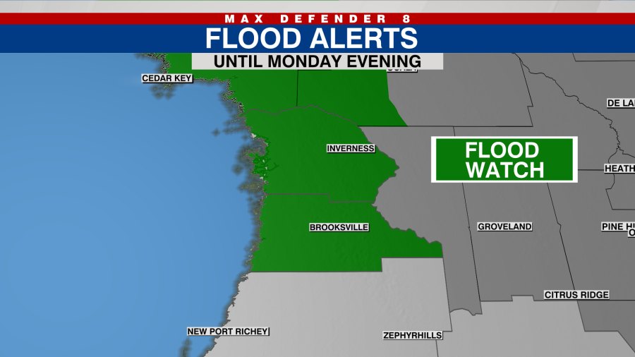
Pasco County remains under a Level 2 flash flood risk Monday, Aug. 3, with the National Weather Service forecasting a 70 percent chance of rain and numerous showers through the evening across the Wesley Chapel area.
The Level 2 risk, on a scale of 1 to 4, covers portions of Pasco, Hernando, and Citrus counties, according to WFLA meteorologist Juliana Mejia reporting Sunday, Aug. 2. A Level 1 risk blankets the entire Tampa Bay region. The elevated rating means localized flooding of urban areas and low-lying spots with poor drainage is possible.
A formal Flood Watch issued by the NWS covers neighboring Citrus, Hernando, and Levy counties through 8 p.m. Monday. While Wesley Chapel falls outside that watch boundary, the same weather system is driving heavy rain across inland Pasco.
What to expect Monday
The NWS Inland Pasco zone forecast calls for partly sunny skies with scattered thunderstorms and numerous afternoon showers. Highs will reach the upper 80s, several degrees below normal August temperatures in the low 90s. South winds 5 to 10 mph will shift southwest in the afternoon.
Monday night brings mostly cloudy skies with scattered thunderstorms and numerous showers, mainly in the evening. Lows will settle in the mid-70s with a 70 percent chance of rain continuing.
Rainfall totals and flooding concern
The NWS Area Forecast Discussion, issued early Sunday, warned that storm total rainfall through Monday could reach 4 to 8 inches across the watch area, with locally higher amounts likely. Precipitable water values at or above 2.25 inches are fueling the heavy downpours.
The Weather Prediction Center placed much of the Nature Coast in a "slight risk" for excessive rainfall Sunday and Sunday night, meaning a 15 to 39 percent chance of exceeding flash flood guidance.
Coastal hazards
A High Rip Current Risk extends across the entire Tampa Bay coastline as of Monday and into portions of the Nature Coast, driven by deep southwest flow ahead of a stalled frontal boundary. The WWSB beach forecast confirmed rip currents are the primary concern for swimmers, even with surf running just 1 to 2 feet.
Southwest winds gusted up to 20 mph Sunday, with seas running 2 to 4 feet and occasional waves reaching 5 feet. A Small Craft Advisory that covered waters from Tarpon Springs to the Suwannee River expired at 8 p.m. Sunday.
What's next
Conditions are expected to improve Tuesday, Aug. 4, with rain chances dropping to 50 percent and partly sunny skies returning. Rain chances climb back to 70 percent Wednesday with numerous afternoon showers and thunderstorms. The upper-level trough driving the current pattern is forecast to lift away from the area early in the week.
Residents in flood-prone areas should avoid driving through standing water and monitor drainage near their properties. No sandbag stations or shelter openings have been announced by Pasco County Emergency Management for this event.





.jpg)